

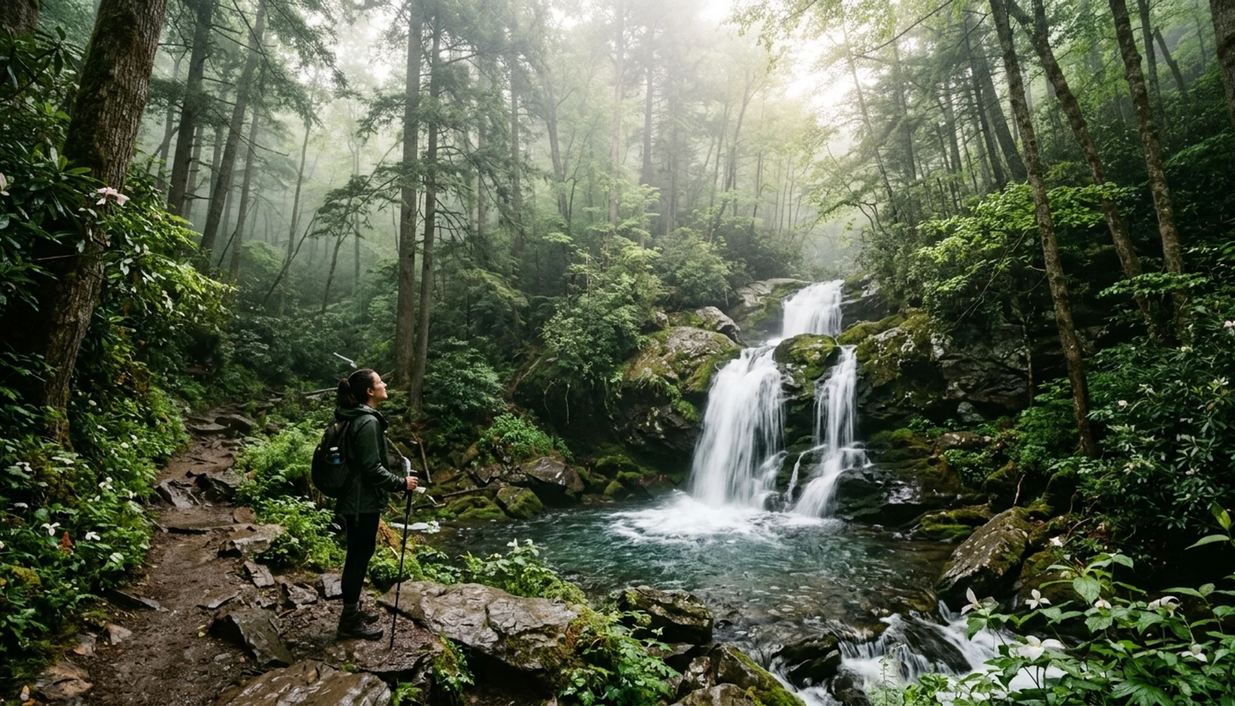
Hidden hiking trails Great Smoky Mountains reveal the park’s true character away from tourist crowds. While popular destinations like Laurel Falls see thousands of visitors daily, these seven lesser-known paths offer solitude, dramatic scenery, and the wilderness experience that drew you to the mountains in the first place. Each trail features unique rewards, from secret waterfalls to panoramic views, accessible through quieter trailheads that locals have treasured for decades.
TL;DR: Hidden Smoky Mountain Trails
- Porter’s Creek Trail: 4 miles roundtrip through historic homestead ruins with spring wildflowers and 30-foot Fern Branch Falls
- Deep Creek Trail: 4.4 miles to three waterfalls including 80-foot Tom Branch Falls, best accessed via Bryson City entrance
- Rich Mountain Loop: 8.5 miles with mountain views and historic cabin, starting from Cades Cove back roads
- Kephart Prong Trail: 4.2 miles to historic CCC shelter ruins through old-growth forest along rushing stream
- Baskins Creek Falls: 3 miles via unmarked path to 30-foot waterfall, accessed through Roaring Fork Motor Nature Trail
- Cove Mountain Trail: 5.8 miles with panoramic views of Cades Cove, starting from Laurel Creek Road
- Best access times: Weekday mornings before 9 AM or after 4 PM for minimal crowds
These trails remain hidden because they lack the marketing presence of Gatlinburg’s main attractions, require slightly more navigation skill, or demand longer drives to remote trailheads. That obscurity becomes your advantage, delivering the authentic mountain experience without competing for parking spaces or perfect photo spots.
The Great Smoky Mountains National Park contains over 800 miles of hiking trails, yet most visitors concentrate on just a dozen popular routes. This creates a unique opportunity for hikers willing to explore beyond the obvious choices. Each hidden trail featured here has been selected based on three criteria: genuine scenic beauty, manageable difficulty for most hikers, and significantly fewer crowds than comparable mainstream options.

Which Hidden Trails Offer the Best Solitude?
Porter’s Creek Trail delivers the most reliable solitude among waterfall hikes. This 4-mile roundtrip journey begins at the Greenbrier entrance, 6 miles east of Gatlinburg via Highway 321. The gravel road to the trailhead deters casual visitors, creating a natural filter that keeps crowds manageable even during peak seasons.
The trail follows Porter’s Creek through a landscape rich with Appalachian history. Stone foundations and chimney remnants mark former homesteads where mountain families lived before park establishment in the 1930s. Spring brings exceptional wildflower displays, particularly trillium and bloodroot carpeting the forest floor from mid-April through May.
Fern Branch Falls appears after 2 miles, a 30-foot cascade tumbling over moss-covered rocks into a clear pool. Most hikers turn back here, but continuing another mile leads to additional ruins and smaller falls. The return journey offers different perspectives on the same scenery, particularly beautiful when afternoon light filters through the canopy.
Deep Creek Trail near Bryson City provides North Carolina’s gateway to Smoky Mountain solitude. The 4.4-mile trail passes three distinct waterfalls: Juney Whank Falls at 0.6 miles, Indian Creek Falls at 1 mile, and Tom Branch Falls at 2.2 miles. Tom Branch Falls impresses most with its 80-foot drop into a swimming hole popular with locals during summer months.
Access requires driving to Deep Creek Campground near Bryson City, approximately 45 minutes from Gatlinburg but worth the extra distance for significantly reduced crowds. The trail follows an old railroad grade, making for easy walking with gentle elevation gain. Parking fills quickly on summer weekends, but weekday visits often yield near-empty lots.
How Do You Find Secret Waterfalls Without Crowds?
Baskins Creek Falls represents the ultimate hidden waterfall, accessible only through local knowledge and careful navigation. No official trail leads directly to this 30-foot cascade, requiring a 3-mile roundtrip hike through unmarked but well-worn paths.
Begin at the Roaring Fork Motor Nature Trail, parking at the Baskins Creek Trail parking area (not the falls trail itself). Cross the road and look for a faint path heading downhill toward the creek. The route follows old logging roads and creek beds, requiring basic trail-finding skills and comfortable scrambling over rocks.
The waterfall reward justifies the extra effort. Baskins Creek Falls tumbles into a secluded amphitheater surrounded by rhododendron thickets. During summer, the pool below offers refreshing swimming opportunities away from crowded swimming holes elsewhere in the park.
Navigation tips: Download offline maps before attempting this hike, as cell service disappears quickly. Bring a physical compass as backup. The path crosses the creek multiple times, so waterproof boots prove essential during high water periods.
Kephart Prong Trail offers another waterfall option with historical significance. The 4.2-mile roundtrip trail starts from the Kephart Prong Trailhead on Newfound Gap Road, 7 miles north of Gatlinburg. This location sits between major tourist routes but receives minimal attention because it lacks the marketing presence of nearby attractions.
The trail follows Kephart Prong through old-growth hemlock forest to the ruins of a Civilian Conservation Corps camp from the 1930s. Stone foundations and metal remnants tell the story of young men who built much of the park’s early infrastructure. Several small waterfalls punctuate the journey, each offering photo opportunities without the crowds found at more famous cascades.
What Mountain Views Rival Popular Overlooks?
Cove Mountain Trail provides panoramic views of Cades Cove without the automotive traffic that defines the loop road experience. This 5.8-mile roundtrip hike starts from Laurel Creek Road, accessible by driving 1.2 miles past the Cades Cove Loop Road entrance and turning right at the gravel parking area.
The trail climbs steadily through mixed hardwood forest, gaining 1,200 feet of elevation over 2.9 miles. Unlike crowded overlooks reached by car, this summit offers 360-degree views including the cove’s historic fields, surrounding ridgelines, and distant peaks extending into Tennessee and North Carolina.
Timing matters significantly for this hike. Early morning visits (before 9 AM) provide the best combination of clear views and minimal crowds. Afternoon thunderstorms frequently develop during summer months, making morning starts essential for safety. Fall foliage season (early to mid-October) delivers spectacular color but requires arriving by 7 AM to secure parking.
Rich Mountain Loop offers an 8.5-mile adventure combining mountain views with historical exploration. The loop starts from the Cades Cove area but begins at the less-obvious Rich Mountain Road rather than the main loop entrance. Drive past the Cades Cove Loop Road entrance, continue straight on Rich Mountain Road for 1.2 miles, and park at the small gravel lot on the right.
This trail visits the John Oliver Cabin, one of the park’s best-preserved log structures, plus provides multiple viewpoints overlooking Cades Cove from above. The historical cabin offers a glimpse into 19th-century mountain life, complete with period furnishings and interpretive displays that receive far fewer visitors than similar sites on the main loop road.
The loop’s difficulty lies in its length rather than technical challenges. Most elevation gain occurs gradually over the first 4 miles, making it accessible to hikers with moderate fitness levels. Water sources appear regularly along the route, but carry sufficient supplies for the full distance.
When Should You Hike to Avoid Tourist Crowds?
Crowd avoidance requires understanding both daily patterns and seasonal variations that affect trail usage throughout the visitor center area. Most tourists begin hiking between 10 AM and 2 PM, creating a predictable window for solitude-seeking hikers.
Optimal daily timing: Start hikes before 9 AM or after 4 PM for the emptiest trails. Early morning brings additional benefits including wildlife sightings, cooler temperatures, and better photography light. Late afternoon hikes work well for shorter trails but require careful attention to sunset times.
Weekday visits dramatically reduce crowds on all trails, with Tuesday through Thursday offering the most solitude. Weekend warriors concentrate their visits on Saturday and Sunday, leaving Monday through Friday significantly quieter. Even popular trails like portions of the Appalachian Trail see 70-80% fewer hikers on weekdays.
Seasonal considerations reveal distinct patterns. Spring wildflower season (April through May) attracts dedicated photographers and botanical enthusiasts but generates less overall traffic than summer family vacations. Fall foliage (early to mid-October) brings the heaviest crowds, requiring very early starts or alternative timing for hidden trail enjoyment.
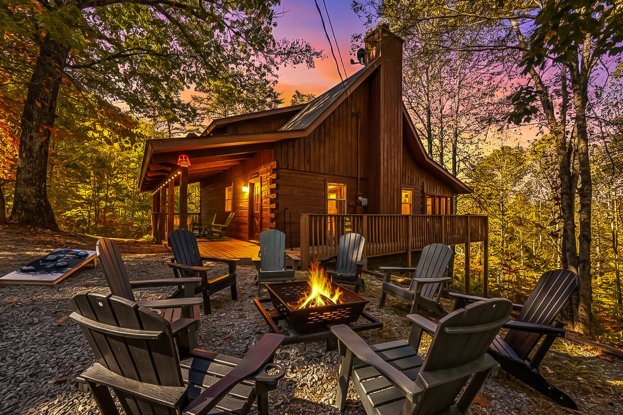
Winter provides the ultimate solitude experience, with some trails receiving only a handful of weekly visitors. Snow and ice require appropriate gear, but the rewards include crystalline air, frozen waterfalls, and mountain views unobscured by summer haze. For guests staying at Smoky Mountain Serenity Lodge, just 3.5 miles from the park entrance, winter morning hikes become easily accessible from the rooftop sauna and hot tub retreat.

How Do You Access Trailheads Away from Main Roads?
Hidden trail access requires navigation skills and comfort with gravel roads, creek crossings, and unmarked parking areas. These barriers naturally limit crowds while rewarding prepared hikers with exceptional experiences.
Greenbrier entrance provides access to several hidden trails including Porter’s Creek and Ramsey Cascades alternatives. From Gatlinburg, drive east on Highway 321 for 6 miles, then turn right at the Greenbrier Road sign. The narrow, winding road follows the Little Pigeon River for 3 miles to a small parking area at the road’s end.
This route challenges nervous drivers with its numerous creek fords and single-lane sections, but passenger cars handle the journey easily during normal weather conditions. Spring flooding occasionally closes the road, so check current conditions at the hiking safely resource before attempting access.
Cosby entrance opens doors to the park’s quietest section, featuring trails that receive minimal publicity despite offering exceptional beauty. From Gatlinburg, drive east on Highway 321 for 20 miles to Cosby, then turn right on Highway 32 for 1.2 miles to the campground entrance.
Hen Wallow Falls Trail and Low Gap Trail both start from Cosby Campground, providing waterfall and mountain view options without the crowds found at equivalent trails near Gatlinburg. The extra driving distance deters casual visitors while delivering some of the park’s most pristine wilderness experiences.
Alternative parking strategies help access popular trailheads during busy periods. Arrive early for primary parking, but scout secondary options in advance. Many trails offer multiple access points, with less obvious starting locations providing the same destinations via slightly different routes.
For complex navigation situations, download the NPS Smokies app before leaving cellular coverage. The app includes offline maps and GPS functionality that works without internet connectivity, essential for trails with multiple trail junctions or unmarked paths.
What Safety Considerations Apply to Lesser-Known Trails?
Hidden trails present unique safety challenges beyond those found on well-marked tourist routes. Reduced foot traffic means fewer people around to provide assistance during emergencies, while less obvious paths increase navigation risks.
Bear encounters become more likely on quieter trails where human presence doesn’t regularly disturb wildlife. Black bears actively forage throughout the park, with hidden trails providing preferred habitat due to reduced human disturbance. Make noise while hiking, especially around blind corners and creek crossings where bears might not hear approaching footsteps.
Store all food, toiletries, and scented items in bear canisters or hang them at least 12 feet high and 6 feet from tree trunks. Never attempt to feed or approach bears, even if they appear docile. Back away slowly while making yourself appear large if you encounter a bear at close range.
Weather monitoring becomes critical on remote trails where retreat options are limited. Summer thunderstorms develop rapidly in the mountains, creating lightning hazards on exposed ridges and flash flood risks in creek valleys. Check weather forecasts before departure and turn back immediately if storms approach.
Stream crossings on hidden trails often lack bridges found on popular routes. Spring snowmelt and heavy rain can transform gentle creeks into dangerous torrents within hours. Never attempt to cross swift-moving water above knee depth, and always face upstream while crossing to maintain balance.
Navigation preparation prevents dangerous situations on unmarked or poorly marked trails. Carry a physical map and compass as backup to electronic devices. Learn basic navigation techniques before attempting complex routes. Inform someone of your planned route and expected return time before heading out.
Emergency communication options are limited in mountainous terrain where cell coverage disappears quickly. Personal locator beacons provide satellite-based emergency communication for serious situations. Whistle signals carry further than shouting and conserve energy during emergencies.
Who Should Think Twice Before Trying These Trails?
Physical fitness requirements: Hidden trails often involve longer distances and more challenging terrain than popular alternatives. Hikers with limited experience should build fitness on well-marked trails before attempting remote routes. Heart conditions require medical consultation before tackling elevation gains exceeding 1,000 feet.
Navigation concerns: People uncomfortable with basic map reading or following unmarked paths should stick to well-signed trails until developing these skills. Getting lost on remote trails can quickly become serious, especially during bad weather or approaching darkness.
Weather sensitivity: Those with severe reactions to poison ivy, bee stings, or seasonal allergies should exercise extra caution on overgrown trails where exposure risks increase. Spring hiking through rhododendron thickets can trigger significant allergic reactions in sensitive individuals.
What Local Secrets Enhance Hidden Trail Experiences?
Local knowledge transforms hidden trail visits from simple hikes into rich explorations of Appalachian culture and natural history. These insights come from decades of mountain experience and conversations with longtime residents who remember the area before tourist development.
Seasonal timing secrets maximize each trail’s unique rewards. Porter’s Creek Trail showcases spring wildflowers best during the narrow window between snowmelt and leaf-out, typically lasting just 2-3 weeks in mid-April. Deep Creek trails offer the most refreshing swimming during late summer when water levels stabilize but air temperatures remain warm.
Baskins Creek Falls flows strongest during spring runoff (March through May) but becomes more accessible for swimming during lower summer flows. Photography enthusiasts find the best light at Cove Mountain overlooks during winter months when deciduous trees allow clear views and crisp air enhances distant mountain visibility.
Wildlife observation tips increase chances of memorable encounters. Dawn and dusk provide optimal timing for deer, bear, and wild turkey sightings along quieter trails. Salamanders become active during rainy periods, with Porter’s Creek and Kephart Prong offering exceptional diversity for amphibian enthusiasts.
Bird watching peaks during spring migration (late April through early May) when northern species pause in the mountains while traveling to breeding grounds. Hidden trails provide better opportunities than popular routes because reduced human noise allows for easier bird detection and approach.
Historical context adds depth to trail experiences beyond simple hiking. Most hidden trails follow routes used by Cherokee hunters, European settlers, or logging operations before park establishment. Stone foundations, old roadbeds, and cemetery sites appear regularly along these paths for observant hikers.
The Porters Creek Trail passes multiple homestead sites where families lived for generations before federal acquisition. Metal artifacts, fruit trees, and non-native plants mark these locations, telling stories of mountain life that ended less than 100 years ago.
Photography techniques adapted to hidden trail conditions improve image quality beyond basic snapshots. Waterfall photography benefits from polarizing filters that reduce glare and enhance color saturation. Long exposures (2-5 seconds) smooth flowing water while maintaining sharp surrounding details.
Mountain view photography works best during periods of stable high pressure when atmospheric haze clears. Early morning and late afternoon provide optimal light angles that illuminate distant ridges while avoiding harsh midday shadows. Guests staying at properties like Forest Creek Retreat benefit from its proximity to these optimal photography windows, just minutes from multiple hidden trail access points.
Frequently Asked Questions
How difficult are these hidden trails compared to popular Smoky Mountain hikes?
Most hidden trails feature moderate difficulty levels similar to popular alternatives but with longer approach distances or rougher trail surfaces. Porter’s Creek Trail offers easier walking than Laurel Falls with gentler elevation gain over 4 miles versus 2.6 miles. Deep Creek trails provide comparable difficulty to Cataract Falls but require longer drives to trailheads. Navigation skills become more important than physical fitness for most hidden trail success.
What permits or fees are required for these lesser-known trails?
No permits are required for day hiking on any trails mentioned, as they all lie within Great Smoky Mountains National Park’s free access areas. Parking fees do not apply to national park trailheads, unlike some state parks in the region. Backcountry camping requires permits and advance reservations, but day hiking remains completely free throughout the park system.
How do water levels affect accessibility to hidden waterfalls?
Spring runoff (March through May) creates the most dramatic waterfall displays but can make creek crossings dangerous on trails like Baskins Creek Falls. Summer and fall provide safer crossing conditions with reduced but still scenic water flows. Winter offers unique frozen waterfall views but requires ice cleats and careful footing. Check recent rainfall patterns before attempting any waterfall hikes, as flash flooding can occur rapidly in mountain watersheds.
What cell phone coverage should I expect on remote trails?
Cell coverage disappears quickly once you leave main roads and visitor centers. Verizon and AT&T provide the most reliable coverage in the Gatlinburg area, but all carriers lose signal within 1-2 miles of trailheads on hidden routes. Download offline maps and inform someone of your planned route before departure. Personal locator beacons offer satellite-based emergency communication for serious situations.
Are these trails suitable for hiking with children?
Porter’s Creek Trail and the first mile of Deep Creek Trail work well for families with children over 8 years old who can handle 4-mile roundtrip distances. Baskins Creek Falls requires scrambling skills unsuitable for young children. Rich Mountain Loop and Cove Mountain Trail demand fitness levels typically beyond most children under 12. Consider children’s hiking experience, fitness level, and attention span before attempting longer hidden trails.
What’s the best time of year to attempt all seven hidden trails?
Late spring (early to mid-May) provides optimal conditions for most hidden trails, combining wildflower displays, moderate temperatures, full water flows, and manageable insect populations. Fall offers excellent visibility and comfortable temperatures but brings increased crowds even on hidden trails. Winter provides maximum solitude but requires appropriate cold weather gear and ice cleats for safety.
How do I find unmarked trails like Baskins Creek Falls?
Unmarked trails require basic navigation skills including map reading, compass use, and route-finding ability. Start with well-marked hidden trails like Porter’s Creek to build confidence before attempting unmarked routes. Join local hiking groups or hire Guide to the Smokies services for initial unmarked trail experience. Always carry backup navigation tools and inform others of your planned route when attempting unmarked paths.
Conclusion
These seven hidden hiking trails Great Smoky Mountains deliver the wilderness experience that mainstream destinations cannot match. While popular trails serve their purpose for quick introductions to the park, these lesser-known routes reveal the authentic character that defines Appalachian mountain culture. Each trail rewards extra effort with genuine solitude, dramatic natural beauty, and connection to the region’s rich history.
Success on hidden trails requires preparation, respect for natural challenges, and comfort with basic navigation skills. The reward system works simply: invest more effort in planning and execution, receive exponentially greater experiences in return. These trails remain hidden not due to inferior quality but because they demand slightly more from visitors than tourist-oriented alternatives.
For 2026 and beyond, these routes will continue providing refuge from increasingly crowded popular destinations. As the Smoky Mountains attract growing visitor numbers, the gap between mainstream and hidden trail experiences will only widen, making local knowledge increasingly valuable for authentic mountain adventures.

After discovering these hidden gems, Smoky Mountain Serenity Lodge provides the perfect recovery retreat. Located just 3.5 miles from the park entrance, the rooftop terrace with cedar sauna and hot tub creates the ideal end to challenging trail days. Check availability here.