
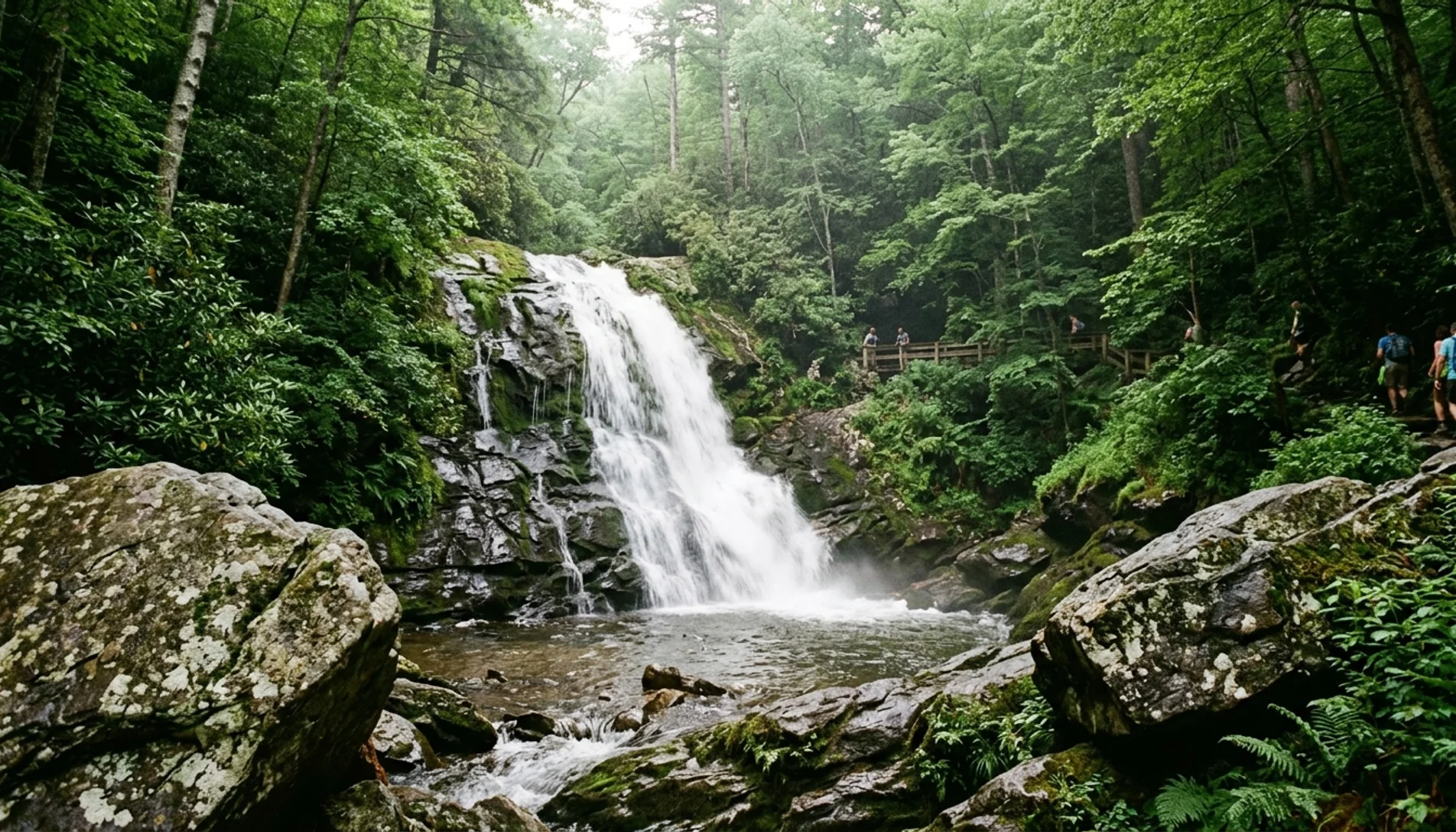
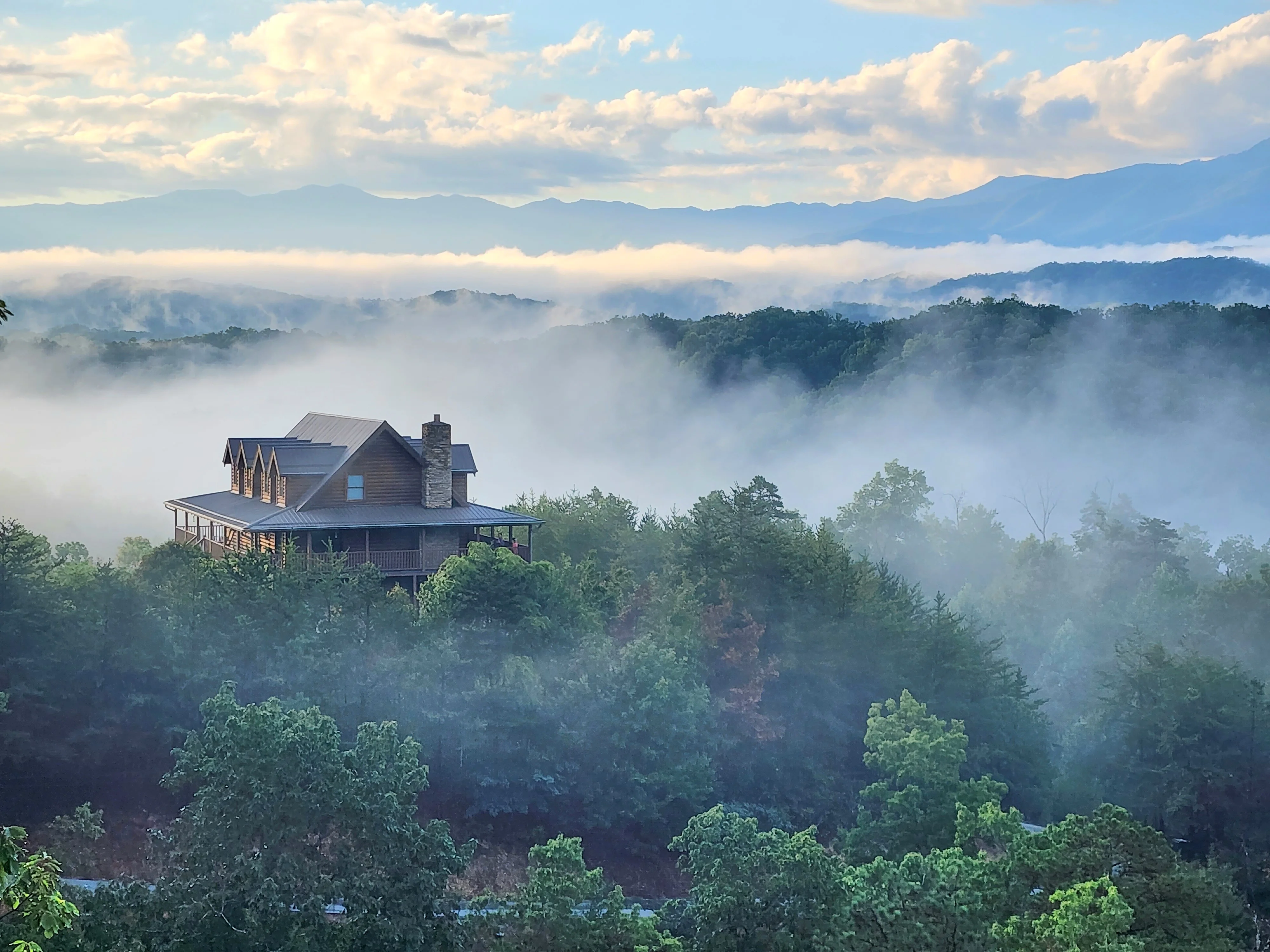
Laurel Falls is a 2.6-mile roundtrip paved trail in Great Smoky Mountains National Park that leads to an 80-foot waterfall, making it one of the most visited hikes in the entire national park system. As of 2026, the trail is currently closed for an 18-month rehabilitation project that began January 6, 2026, with a projected reopening around mid-2026. If you are planning a Smoky Mountains visit, read the current closure status and explore the alternate hike options below before heading out.
Quick Summary
- Laurel Falls Trail is a 2.6-mile roundtrip paved hike inside Great Smoky Mountains National Park leading to an 80-foot waterfall.
- The trail closed on January 6, 2026 for an estimated 18-month rehabilitation; the projected reopening window is mid-2026 per the National Park Service.
- The trailhead sits on Little River Road, 3 miles west of Sugarlands Visitor Center; a paid parking tag is required for stays over 15 minutes.
- Pets are not allowed on Laurel Falls Trail; only the Gatlinburg Trail and Oconaluftee River Trail permit leashed pets inside the park.
- Four strong alternate waterfalls and loop hikes exist nearby, including Grotto Falls (4 miles roundtrip) and Lynn Camp Prong Cascades (1.4 miles roundtrip).
- Sevierville and Gatlinburg cabin rentals from Hemlock Hills Cabin Rentals put you within a short drive of the trailhead and every alternate hike in this guide.
Few waterfall hikes in Tennessee match the draw of Laurel Falls. The trail threads through dense mountain laurel and rhododendron thickets, passes through a mixed hardwood forest, and delivers a split two-tiered cascade that falls 80 feet through a narrow gorge. The paved surface made it accessible for a wide range of hikers, which is exactly why the pavement deteriorated: sections became cracked and uneven from heavy visitor traffic and freeze-thaw cycles, and the 2026 closure gives the National Park Service time to restore it properly.
In 2026, Sevier County generated nearly $3.93 billion in visitor spending in 2026 alone, according to a Sevier County Government press release from August 2026, and Great Smoky Mountains National Park sits at the center of that demand. Planning your trip around current trail conditions, seasonal timing, and the right cabin base camp makes the difference between a frustrating visit and an exceptional one.

Is Laurel Falls Currently Closed?
Yes, Laurel Falls Trail is currently closed. The Laurel Falls Trail official NPS page confirms the closure began on January 6, 2026 and is expected to last approximately 18 months, placing the estimated reopening around mid-2026. As of publication, the National Park Service has not announced a confirmed reopen date, so check the Great Smoky Mountains National Park official site for the latest status before your trip.
The rehabilitation project addresses years of pavement degradation. The paved surface on the trail had developed significant cracks and uneven sections from the combination of heavy foot traffic, tree root growth beneath the asphalt, and repeated freeze-thaw cycles across Smoky Mountain winters. Several sections also posed accessibility concerns for hikers with mobility limitations. The NPS closure allows for a full resurfacing and structural improvement rather than a patchwork repair.
Specifically, the project is expected to include removal and replacement of the deteriorated asphalt trail surface, grading improvements, and drainage corrections to reduce future erosion underneath the new surface. Once complete, the trail should be in significantly better condition than it was before the 2026 closure, with improved accessibility and a longer-lasting surface.
If you arrive at the trailhead during the closure period, the parking area may still be accessible, but barriers block the trail entry. Do not attempt to bypass the closure barriers. Proceeding past a National Park Service closure is a federal citation, and the trail conditions during active construction work pose genuine safety hazards.
How Difficult Is the Hike to Laurel Falls?
Laurel Falls Trail is rated easy to moderate by the National Park Service. The 2.6-mile roundtrip distance is manageable for most fit adults and older children, and the paved surface historically made it one of the more accessible backcountry waterfall hikes in the Smokies. That said, the trail does gain roughly 400 feet in elevation over its 1.3-mile one-way length, which means a noticeable uphill push on the way to the falls.
The grade is steady but never steep. Most hikers describe it as a comfortable walk with a sustained incline rather than a demanding climb. Children as young as five or six typically complete it without difficulty, and grandparents with reasonable fitness often manage it well. The main challenge on the return trip is the downhill grade on a paved surface, which can be slippery after rain. Trekking poles are worth bringing if you have unsteady footing on descents.
Before the closure, the trail did have cracked and uneven sections of pavement that created tripping hazards, particularly for hikers not paying close attention. The post-rehabilitation version should address those issues. Once the trail reopens in mid-2026, expect a smoother walking surface than experienced visitors may remember from previous years.
One detail competitors consistently omit: the trail’s elevation gain of approximately 400 feet is almost entirely front-loaded in the first half mile, making the opening stretch the most demanding section. After that initial climb, the grade levels considerably, and the forest understory opens up with mountain views on clear days. Reaching the falls feels genuinely earned.
How Long Is the Hike to Laurel Falls in Tennessee?
The Laurel Falls hike is 2.6 miles roundtrip (approximately 4.2 kilometers), with a one-way distance of 1.3 miles from the trailhead to the base of the falls. Most hikers complete the round trip in 1.5 to 2.5 hours, depending on pace and time spent at the waterfall itself. Budget closer to 2 hours if you plan to photograph the falls, eat a snack, or wait for the crowd to thin.
The trailhead is located on Little River Road, 3 miles west of Sugarlands Visitor Center. If you are unfamiliar with the route, take US-441 through Gatlinburg into the park and follow signs toward Cades Cove, then watch for the Laurel Falls Trailhead pulloff on your left. The nearest restroom is at Sugarlands Visitor Center, not at the trailhead itself. Stop there before driving the 3 miles to the trailhead to avoid a backtrack.
Parking at the Laurel Falls Trailhead fills early, particularly from June through October. Arriving before 9:00 AM gives you the best chance of securing a spot. The National Park Service recommends using the park’s shuttle system as an alternative when lots are full. A parking tag is required for any vehicle parked in Great Smoky Mountains National Park for more than 15 minutes; daily and annual tags can be purchased at entrance stations, at the Sugarlands Visitor Center, or online via the NPS reservation system.
Why Is Laurel Falls Closed in Tennessee?
Laurel Falls Trail is closed because the paved trail surface deteriorated to a point where continued use posed both safety risks and long-term damage to the trail corridor. The National Park Service officially closed the trail on January 6, 2026 for a rehabilitation project expected to last 18 months. The closure is not weather-related or seasonal but a planned infrastructure repair funded through NPS maintenance programs.
The root cause is a combination of factors that compound over time on heavily trafficked paved trails. First, the original asphalt absorbed decades of freeze-thaw cycling across Smoky Mountain winters, causing progressive cracking. Second, tree roots beneath the trail pushed upward against the pavement, creating raised sections and tripping hazards. Third, drainage issues let water pool beneath the surface during heavy rain events, accelerating subsurface erosion and undermining the structural base of the trail.
Laurel Falls Trail consistently ranks among the most visited trails in all of Great Smoky Mountains National Park. That volume compresses the timeline for surface degradation significantly compared to lower-traffic trails. What might take 30 years to deteriorate on a lightly used backcountry path can deteriorate in under 15 years on a trail seeing this level of daily foot traffic.
The rehabilitation project is designed to be a lasting fix rather than a surface patch. Expect improved drainage infrastructure, a completely new trail surface, and corrected grade sections that should extend the trail’s next maintenance cycle considerably. Smokies Life, the official nonprofit partner of Great Smoky Mountains National Park, periodically publishes project updates and conservation news that can supplement the official NPS trail status page for those wanting more detail.
What Are the Best Alternate Hikes Near Laurel Falls?
Four excellent waterfall and forest hikes near Laurel Falls provide strong alternatives during the 2025-2026 closure period. Each covers different terrain, difficulty levels, and scenery, so your choice depends on group fitness, time available, and whether you want a waterfall payoff or a more expansive trail experience.
Grotto Falls (4 miles roundtrip)
Grotto Falls is the closest comparable waterfall experience. The 4-mile roundtrip trail climbs through an old-growth hemlock forest along Trillium Gap Trail and delivers a 25-foot waterfall you can actually walk behind, an experience Laurel Falls does not offer. The trail gains more elevation than Laurel Falls (approximately 500 feet), so rate it moderate rather than easy. Trailhead access is via Roaring Fork Motor Nature Trail, which is closed in winter, making Grotto Falls a spring through fall option.
Lynn Camp Prong Cascades (1.4 miles roundtrip)
At 1.4 miles roundtrip, Lynn Camp Prong Cascades is the shortest waterfall hike on this list and arguably the best option for families with very young children or guests with limited mobility. The cascade runs along a wide creek bed with multiple small drops rather than a single tall fall. The trail is unpaved and follows an old railroad grade, keeping the grade nearly flat throughout. Access via Tremont Road off the Townsend entrance makes it most convenient for hikers based in Pigeon Forge or Sevierville.
Little River, Cucumber Gap, Jakes Creek Loop (5.4 miles roundtrip)
This loop combines three trails into a 5.4-mile circuit that passes through varied forest types, follows Little River for much of its length, and crosses several footbridges. It is the best option for hikers who want a longer day on the trail and do not want to retrace their steps. Difficulty is moderate with roughly 600 feet of total elevation change spread across the full loop. The trailhead is at the Elkmont Campground area, making it accessible from both Gatlinburg and Pigeon Forge directions.
Gatlinburg Trail (4 miles roundtrip)
Gatlinburg Trail is unique because it is one of only two trails in Great Smoky Mountains National Park that permit leashed pets. If you are hiking with a dog, this is your best park option while Laurel Falls remains closed. The trail follows the West Prong of the Little Pigeon River with minimal elevation gain, making it the flattest option on this list. The 4-mile roundtrip is accessible from the Sugarlands Visitor Center parking area, meaning no additional parking tag is required if you stop there first.
| Trail | Distance (Roundtrip) | Difficulty | Pets Allowed | Seasonal Limits |
|---|---|---|---|---|
| Grotto Falls | 4.0 miles | Moderate | No | Closed in winter (Roaring Fork Road) |
| Lynn Camp Prong Cascades | 1.4 miles | Easy | No | Year-round |
| Little River / Cucumber Gap Loop | 5.4 miles | Moderate | No | Year-round |
| Gatlinburg Trail | 4.0 miles | Easy | Yes (leashed) | Year-round |
What Is the Best Season to Visit Laurel Falls?
The ideal time to hike Laurel Falls, or the alternate hikes nearby, depends on your priorities. Spring (late March through May) is the strongest overall choice for most visitors: waterfall volume runs high from snowmelt and spring rains, mountain laurel blooms typically peak in late May through early June, and rhododendron follows in June and July. The trail earns its name from the mountain laurel corridor you walk through, and hiking it in full bloom elevates the experience considerably above a bare-winter or drought-summer visit.
Fall (mid-October through early November) brings the other peak window. Hardwood foliage in the Smokies turns reliably in mid-October, with peak color varying slightly by elevation. Laurel Falls sits at a mid-elevation zone where leaf color typically peaks in the third and fourth weeks of October. The downside: fall is the busiest season in Sevier County, and trailhead parking becomes extremely competitive. Arriving before 8:00 AM during peak foliage weeks is not optional, it is necessary.
Summer (June through August) brings the heaviest crowds and the hottest midday temperatures. If you plan a summer visit, start hiking by 7:30 or 8:00 AM. The trail is substantially more pleasant before 10:00 AM, before the heat builds and before the parking lot reaches capacity. Afternoon thunderstorms roll through the Smokies regularly in summer, particularly in July and August, and paved trails get slippery fast.
Winter (December through February) offers the least crowded conditions and occasionally spectacular ice formations on the upper falls when temperatures drop below freezing for several consecutive nights. But winter is also when trail surfaces are most treacherous, and the road to Roaring Fork Motor Nature Trail closes entirely, eliminating Grotto Falls as an option. Microspikes are worth packing for any winter or early spring visit to the Smokies.
Photography Tips for Laurel Falls and Nearby Waterfalls
Laurel Falls and the alternate hikes nearby are among the most photographed natural subjects in Great Smoky Mountains National Park. A few practical photography tips can dramatically improve what you bring home, and most guides skip this entirely.
Overcast days produce better waterfall photographs than sunny days. Direct sunlight creates harsh shadows in the gorge and blows out the white water, making the cascade look flat. An overcast or lightly overcast sky acts as a natural diffuser. The Smokies are overcast frequently, so this is not a difficult condition to hit.
For long-exposure shots that render the water as smooth silk, a tripod and a neutral density (ND) filter are standard tools. A 3-stop ND filter in daylight gives you enough flexibility to shoot at 1-2 seconds, which is the range that smooths moving water without making it disappear entirely. Bring a remote shutter release or use your camera’s timer to eliminate shake.
The best angle at Laurel Falls, when the trail reopens, is from the lower viewing area looking slightly upward at the point where the upper and lower sections of the falls meet. The split in the falls creates a natural V shape that gives photographs visual structure. Most visitors photograph from the same trail-level position; stepping slightly to the left of center puts the split in the foreground and the upper falls in the background.
For Grotto Falls, the behind-the-falls angle is the signature shot. Position yourself in the shallow water behind the curtain and shoot outward with the falls framing the trail and forest beyond. This works best with a wide-angle lens set between 16mm and 24mm (full-frame equivalent). Waterproof sandals or neoprene socks are useful here as the rocks behind the falls are constantly wet.
Practical Trail Tips Most Guides Miss
A few logistics that rarely appear in trail guides but regularly catch visitors off guard in the Smokies.
Parking tags are not optional. Great Smoky Mountains National Park requires a parking tag for any vehicle staying more than 15 minutes. Tags cost $5 daily or $15 annually (verify current pricing at the entrance station, as the NPS periodically adjusts fees). If you park without a tag and a ranger checks the lot, the citation cost is significantly higher than the tag itself.
The nearest restroom is 3 miles away. There are no facilities at the Laurel Falls Trailhead. The Sugarlands visitor center has restrooms, water fountains, and a bookstore. Stop there before driving to the trailhead rather than hoping to manage the roundtrip without facilities.
Cell service is unreliable. Signal drops in the valley sections of the trail. Download an offline map before you leave. GAIA GPS is a reliable option for downloading trail routes to your phone for offline navigation, useful if you plan to explore beyond the main trail or connect to one of the alternate loops.
Bear activity is real and routine. Great Smoky Mountains National Park has a dense black bear population. Bears are attracted to food smells. Pack all snacks in a sealed container inside your pack, not in exterior pockets. Do not eat on the trail near other hikers’ packs. Bear spray is not required but is a reasonable precaution for early morning hikes when bear activity is highest.
The shuttle is genuinely useful. On busy summer and fall weekends, the trailhead lot fills by 9:00 AM. The park shuttle system runs from Sugarlands Visitor Center and eliminates the parking problem entirely. Check the current shuttle schedule on the NPS website before your visit, as operational hours vary by season. Review NPS guidelines on hiking safely in the Smokies before any trail visit.
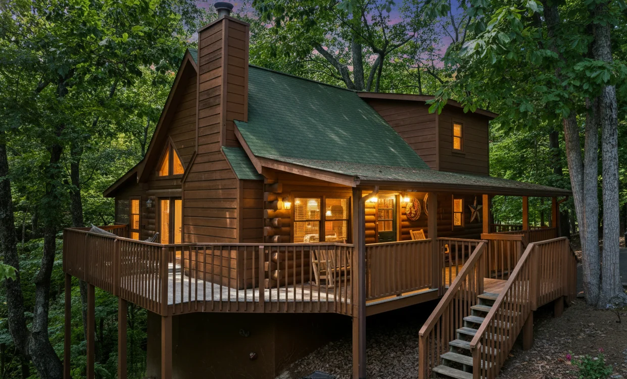
Where Should You Stay for Hiking the Laurel Falls Area?
Your cabin base matters as much as your trail plan when hiking in Great Smoky Mountains National Park. The Laurel Falls Trailhead sits on Little River Road between Gatlinburg and Townsend, making Gatlinburg and Sevierville the two most convenient anchor points. Pigeon Forge works as well, with a 20 to 30-minute drive to the Sugarlands Visitor Center depending on traffic.
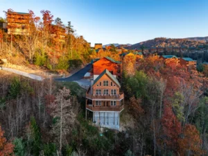
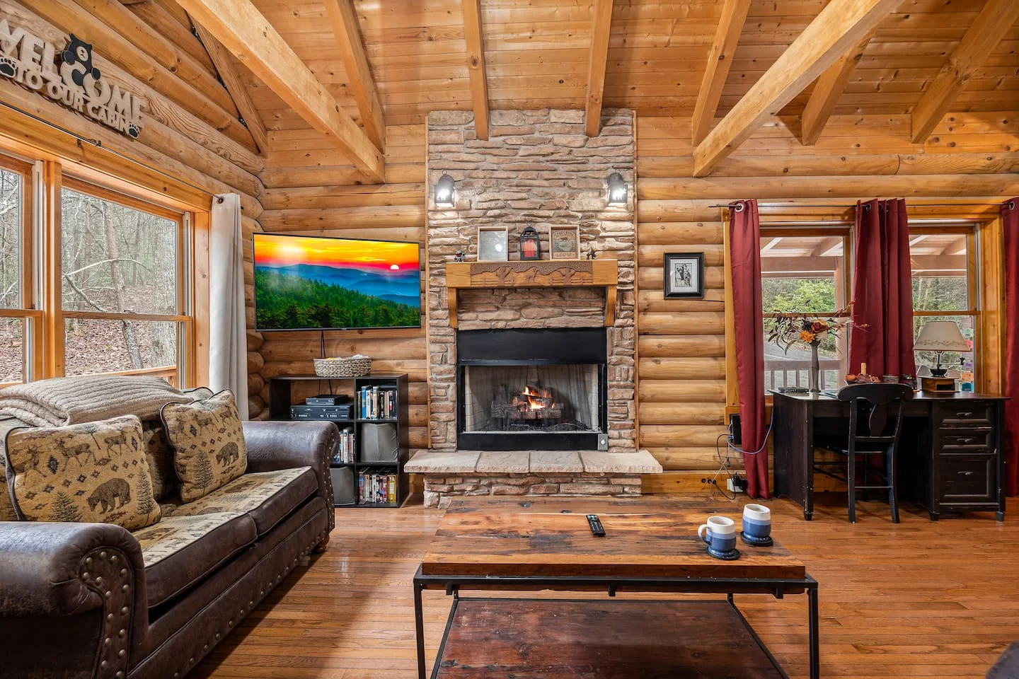
For hikers prioritizing trail access over proximity to attractions, a Gatlinburg-area cabin cuts the drive to Sugarlands Visitor Center to under 15 minutes. The Spirit Bear sits in Gatlinburg’s Arts and Crafts Community, placing you minutes from the park entrance with three private king suites, a covered fire pit, and a hot tub on the wooded lot. After a full day on the trail, the hot tub does genuine work. The cabin sleeps 8 across 3 bedrooms, a practical size for two couples or a family group.
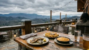
If you prefer a Sevierville base with more space, Smoky Mountain Serenity Lodge at The Lodges of Reedmont offers a rooftop terrace with a cedar sauna, a private hot tub, and two outdoor fireplaces alongside a gourmet marble kitchen. The Speakeasy game room keeps the group entertained on rainy days when trails are slippery. It sleeps up to 16 guests across 3 bedrooms and 3 bathrooms, making it one of the more versatile properties in the Hemlock Hills portfolio for groups planning multi-day hiking itineraries.
Families with young children who want a property near the Pigeon Forge side of the park might consider Mountain Memories, a three-story Sevierville cabin less than 3 miles from Dollywood and with easy access toward the Townsend entrance of the park. The fire pit and hot tub are highlights for family evenings after trail days, and the double decks provide good outdoor space for gear drying and morning coffee. Browse the full selection of Sevierville cabins or Gatlinburg cabins to match your group size and preferred amenities to the right property.
Pet owners face one specific constraint worth planning around: Laurel Falls Trail does not permit pets, and neither do most park trails. But the Gatlinburg Trail (one of the alternate hikes above) does allow leashed dogs. If you are bringing a dog, Little Bear in Cedar Falls Resort welcomes dogs under 75 pounds, and its location near Pigeon Forge keeps you close to the Townsend entrance for the Gatlinburg Trail access point. Check the full pet-friendly cabin listings to see which properties accept your specific pet size.
Combining Laurel Falls with Other Smoky Mountain Stops
The Laurel Falls Trailhead sits in a particularly convenient location for combining with other park experiences in a single day. The full itinerary below assumes the trail has reopened; if still closed during your visit, swap the hike for one of the alternate waterfall options listed above.
Start at Sugarlands Visitor Center when it opens, pick up a park map (the paper version is useful for spotting connecting roads), use the restroom, and drive the 3 miles to the Laurel Falls Trailhead. Complete the hike in 2 hours. From the trailhead, Little River Road continues west toward Cades Cove, one of the most wildlife-rich valleys in the eastern United States. The 11-mile loop road at Cades Cove offers reliable white-tailed deer sightings year-round and black bear sightings most reliably in spring and fall mornings. Plan 2 to 3 hours for Cades Cove.
Alternatively, drive back through Gatlinburg for lunch and take Roaring Fork Motor Nature Trail in the afternoon. The one-way road passes several historic cabin structures and provides access to the Grotto Falls trailhead, so you can combine a second waterfall hike on the same day if the group has energy. Roaring Fork closes in winter, limiting this combination to spring through fall.
If your group includes non-hikers or younger children done with the trail by midday, the drive down to the Gatlinburg Parkway puts you within minutes of Anakeesta, Ripley’s Aquarium of the Smokies, and the SkyLift Park. Dollywood in Pigeon Forge makes a strong second-day anchor if you want one full park day after a trail morning. Pigeon Forge theme parks average around three million visitors per year, so arriving for opening time on both trail and park days avoids the worst of the crowds.
Frequently Asked Questions About Laurel Falls
Is Laurel Falls Trail open right now in 2026?
As of 2026, Laurel Falls Trail may be approaching its projected reopening window. The National Park Service closed the trail on January 6, 2026 for an 18-month rehabilitation project, placing the estimated reopen around mid-2026. Check the official NPS Laurel Falls page for the most current status before visiting, as construction timelines can shift. Do not rely on third-party sources for closure status; the NPS page is the only authoritative source.
How long does the Laurel Falls hike take?
Most hikers complete the 2.6-mile roundtrip hike in 1.5 to 2.5 hours. The pace depends on group fitness, how long you spend at the falls, and trail conditions. Budget 2 hours as a reasonable planning estimate, which includes time at the waterfall for photos and a snack stop. Add 30 minutes if you are hiking with young children or seniors.
Do you need a reservation to hike Laurel Falls?
No reservation is required to hike Laurel Falls Trail. The hike is a first-come, first-served experience. However, a parking tag is required for any vehicle in the national park for more than 15 minutes. Tags are available at entrance stations, at Sugarlands Visitor Center, and online through the NPS. The trailhead parking lot fills early on weekends and holidays, so arriving before 9:00 AM is strongly recommended during peak season.
Can you bring your dog on the Laurel Falls Trail?
No, pets are not permitted on Laurel Falls Trail. Great Smoky Mountains National Park restricts pets to two trails only: the Gatlinburg Trail and the Oconaluftee River Trail. Both are paved, relatively flat walks that follow river corridors. If you are hiking with a dog, the Gatlinburg Trail is the best available option in the park and is accessible from the Sugarlands Visitor Center area.
What is the elevation gain on the Laurel Falls hike?
Laurel Falls Trail gains approximately 400 feet in elevation over the 1.3-mile one-way distance to the waterfall. The climb is most concentrated in the first half mile from the trailhead, after which the grade levels out considerably. This makes the trail easy to moderate in difficulty, manageable for most hikers but noticeably more demanding than a flat river walk.
What are the best alternate hikes near Laurel Falls while it is closed?
Four strong alternatives exist within Great Smoky Mountains National Park: Grotto Falls (4 miles roundtrip, moderate, you can walk behind the falls), Lynn Camp Prong Cascades (1.4 miles roundtrip, easy, best for young children), the Little River and Cucumber Gap Loop (5.4 miles roundtrip, moderate, good for experienced hikers), and Gatlinburg Trail (4 miles roundtrip, easy, the only pet-friendly option). All four are detailed in this guide with distance, difficulty, and access information.
What is the best time of year to visit Laurel Falls?
Late May through early June is ideal for mountain laurel blooms along the trail corridor, which gives the hike its name. Mid-October brings peak fall foliage at the trail’s elevation. Both windows are the most visually rewarding but also the most crowded. For the quietest experience with good waterfall flow, late March through April after winter snowmelt offers strong water volume with noticeably thinner crowds than the summer and fall peak seasons.
What should I know about parking at the Laurel Falls Trailhead?
The Laurel Falls Trailhead parking lot on Little River Road fills quickly, often by 9:00 AM on summer and fall weekends. A parking tag is required for all vehicles staying more than 15 minutes in Great Smoky Mountains National Park. The NPS shuttle system offers an alternative from Sugarlands Visitor Center when lots are full. There are no restroom facilities at the trailhead itself; the nearest facilities are at Sugarlands Visitor Center, 3 miles east on Little River Road.
Ready to Plan Your Smoky Mountains Hiking Trip?
Whether Laurel Falls reopens during your visit or you spend the day exploring Grotto Falls and the Cades Cove loop instead, the Gatlinburg, Pigeon Forge, and Sevierville corridor puts you within 30 minutes of every major trail in Great Smoky Mountains National Park. The right cabin base makes a hiking-focused trip significantly easier, with a private hot tub at the end of the day doing more recovery work than most hikers expect.
Use our Smoky Mountain Vacation Planner to match your group size, preferred amenities, and travel dates to the right property. For two to four guests, a one-bedroom option like Heavenly View puts you close to park access without paying for space you do not need. For larger families or groups of six or more, a three-bedroom or larger cabin with a game room keeps everyone occupied on rainy trail days.
If you are organizing a hiking trip and want a Gatlinburg-area base, The Spirit Bear sits minutes from the park entrance with a private hot tub, covered fire pit, and three king suites for up to 8 guests. It is the kind of cabin that makes a week of trail days genuinely restorative rather than just tiring. Check availability and current rates here.
Content powered by inkSTR.co